Mapping, GPS & User Tracking
Real-time geo-location and travel-time visibility for every worker.

Built to make mapping, gps & user tracking effortless.
Maintain a real-time view of your entire mobile workforce with integrated GPS, geo-location and user tracking. Monitor travel times, location history and live ETAs directly from the web and mobile apps to improve productivity and boost customer satisfaction.
Key Benefits
- Live geo-location of every technician on an interactive map
- Movement history and travel-time analytics per worker
- Real-time ETAs surfaced in the web console and mobile app
- Geo-fencing to validate on-site arrival and departure
Improve the productivity of your mobile workforce and give your business better visibility with WorkWide Mobile’s Mapping and GPS features.
Our Mapping and GPS tools help you monitor travel times, view location history, optimise routes and track field service workers from your web and mobile apps. Whether your team is completing service calls, installations, deliveries, inspections or maintenance work, WorkWide Mobile gives you a clearer view of where work is happening and how your mobile teams are moving.
Unlike a standalone GPS vehicle tracking system, WorkWide Mobile connects location visibility with job management, scheduling, dispatch, digital job cards, SLA performance and reporting.
This gives your business more than dots on a map. It gives you better control, safer travel routes and a more reliable service experience for your customers.
Mapping and GPS Built for Mobile Workforce Operations
Field service teams do not only need to know where vehicles are. They need to know where people, jobs, tasks and customer sites are in relation to one another.
WorkWide Mobile gives your business practical Mapping and GPS functionality designed for day-to-day field operations. You can monitor field service workers, understand travel routes, track actual distances and support better task coordination across your mobile workforce.
Instead of managing jobs in one system and location visibility in another, WorkWide Mobile brings both together.
This gives managers a more complete view of field operations, from the job location to the technician assigned, the route taken, the expected arrival time and the work completed on-site.
See Where Work Is Happening in Real Time
When teams are spread across different locations, real-time visibility matters.
WorkWide Mobile helps you track the live location of mobile users so your office team can make better operational decisions. This is especially useful when jobs need to be reassigned, urgent tasks come in, or customers need accurate updates.
With WorkWide Mobile’s Mapping and GPS functionality, your business can:
View mobile workers’ current locations
Improve task allocation
Respond faster to urgent jobs
Reduce unnecessary travel delays
Monitor job and route progress
Improve field team accountability
Support safer travel routes
This gives your business better visibility without relying on constant calls or manual check-ins.
WorkWide Mobile Mapping and GPS Features
Comprehensive Location History
WorkWide Mobile gives your team access to detailed task location history.
This helps managers understand where tasks were completed, how field workers moved between locations and how travel activity connects with job execution. Each task can be paired with its relevant history, giving your business a clearer record of field activity.
For service teams, maintenance teams and mobile technicians, location history supports better reporting, accountability and operational planning.
Precision with Geo-Fencing
Geo-fencing allows your business to define specific geographic areas for tasks or users.
This helps ensure work is completed within the correct service area, site or customer location. It also supports better control over field service activity, especially where teams need to work within assigned territories or specific operational zones.
Geo-fencing can help improve task accuracy, service control and visibility across distributed teams.
Real-Time Location Tracking
WorkWide Mobile uses geocoding technology to support real-time visibility of mobile users’ locations.
This helps your business understand where technicians or field workers are during the working day and how their movement relates to assigned tasks. With better location visibility, managers can make faster decisions and support more efficient mobile workforce operations.
For businesses comparing a GPS vehicle tracking system or GPS fleet management system, this is where WorkWide Mobile offers a stronger operational advantage. Location tracking is connected to the work being done, not separated from the job lifecycle.
Mobile ETA Visibility
Customers and office teams both benefit from clearer arrival times.
WorkWide Mobile supports ETA visibility through web messaging or notifications, helping improve communication and task coordination. This gives teams a more transparent way to manage arrival expectations and service updates.
When customers know when to expect a technician or field worker, the overall service experience improves.
Route Optimisation
Efficient routes save time, reduce travel waste and help teams complete more work.
WorkWide Mobile helps improve task routes using waypoints, task priorities and real-time traffic data. Your business can track actual distance and time travelled, giving managers better insight into field performance and route efficiency.
Route optimisation is especially useful for businesses managing multiple jobs, technicians or service areas each day.
Support for GPS Coordinates
WorkWide Mobile supports geocoding and reverse geocoding, helping your business convert human-readable addresses into GPS coordinates and GPS coordinates back into readable addresses.
This improves location tracking and task management, especially when teams need to work across customer sites, remote locations or service areas where accurate mapping matters.
More Than a GPS Vehicle Tracking System
A GPS vehicle tracking system can show where a vehicle is. WorkWide Mobile goes further by connecting location data to the work your teams are doing.
Your business can use Mapping and GPS to support job planning, dispatch decisions, field worker visibility, digital job cards and customer communication from one connected platform.
This helps your team answer practical operational questions, such as:
Which field worker is closest to the next job?
How long will it take to arrive on-site?
Which route is most efficient?
Was the task completed at the correct location?
How much travel time was used?
How does travel activity affect job performance?
Where are delays affecting service delivery?
This is what makes WorkWide Mobile a stronger fit for service-driven businesses that need more than basic tracking.
GPS Fleet Management System for Connected Operations
A GPS fleet management system is most valuable when it supports the full service delivery process.
WorkWide Mobile connects Mapping and GPS with wider mobile workforce management features, helping your business manage people, vehicles, jobs, assets and service performance in one system.
Your Mapping and GPS tools work alongside:
Scheduling and dispatch
Job management
Digital job cards
Asset management
Parts and inventory
SLA management
Contract management
Reporting
Customer service management
By connecting GPS visibility with these operational areas, WorkWide Mobile helps your business move from simple tracking to better field service control.
How Mapping and GPS Improves Job Management
Mapping and GPS becomes more valuable when it is connected to job execution.
WorkWide Mobile links location visibility with mobile workforce management, helping teams manage tasks, routes and field activity from one platform. This means your business can use GPS data to support the way jobs are assigned, completed and reported.
With WorkWide Mobile, Mapping and GPS can help your business:
Match the right field worker to the right job
Track travel time and actual distance
Improve digital job card accuracy
Support faster dispatch decisions
Improve customer communication
Strengthen reporting and accountability
Monitor task completion by location
Reduce delays caused by poor routing
This gives your business a more practical way to manage field service operations from request to completion.
Why Businesses Use WorkWide Mobile Mapping and GPS
Improved Efficiency and Productivity
When teams know where to go, how to get there and what needs to be done, work moves faster.
WorkWide Mobile helps reduce delays by supporting better route planning, clearer task visibility and faster field team coordination.
Better Route Control
Poor routes waste time, fuel and resources.
With route optimisation, waypoints and real-time traffic data, your business can help field workers travel more efficiently between jobs while reducing disruption from traffic or route changes.
Real-Time Visibility
Managers need more than after-the-fact updates.
WorkWide Mobile provides real-time tracking across your mobile workforce, helping your team monitor activity, respond to changes and make informed operational decisions throughout the day.
Stronger Customer Satisfaction
Better visibility leads to better communication.
When your team can provide more accurate arrival updates and manage tasks more efficiently, customers receive a smoother, more reliable service experience.
Safer, Smarter Field Travel
Route planning and location visibility help your business support safer travel routes and better field team coordination.
This keeps employee safety and operational reliability at the centre of your service process.
Built for Field Service and Mobile Teams
WorkWide Mobile is built for businesses that manage people, tasks, vehicles and assets across multiple locations.
Our Mapping and GPS functionality is ideal for:
Field service teams
Maintenance teams
Installation teams
Delivery operations
Facilities management businesses
Telecommunications teams
Security operations
Mining operations
Inspection teams
Businesses managing mobile workers at scale
Whether your team is moving between customer sites, service areas, branches or remote locations, WorkWide Mobile helps you manage location visibility as part of your wider operational workflow.
Curious?
Want to find out how WorkWide can benefit your business?
Request a demo today and see how Mapping and GPS, real-time location tracking, route optimisation and mobile workforce management can help your business improve visibility, productivity and service delivery.
Book a demo and discover how WorkWide Mobile gives your team better control over every route, every task and every field operation.
Measured impact across WorkWide Mobile customer deployments.
Measured impact across WorkWide Mobile customer deployments.
Measured impact across WorkWide Mobile customer deployments.
Where teams put Mapping, GPS & User Tracking to work.
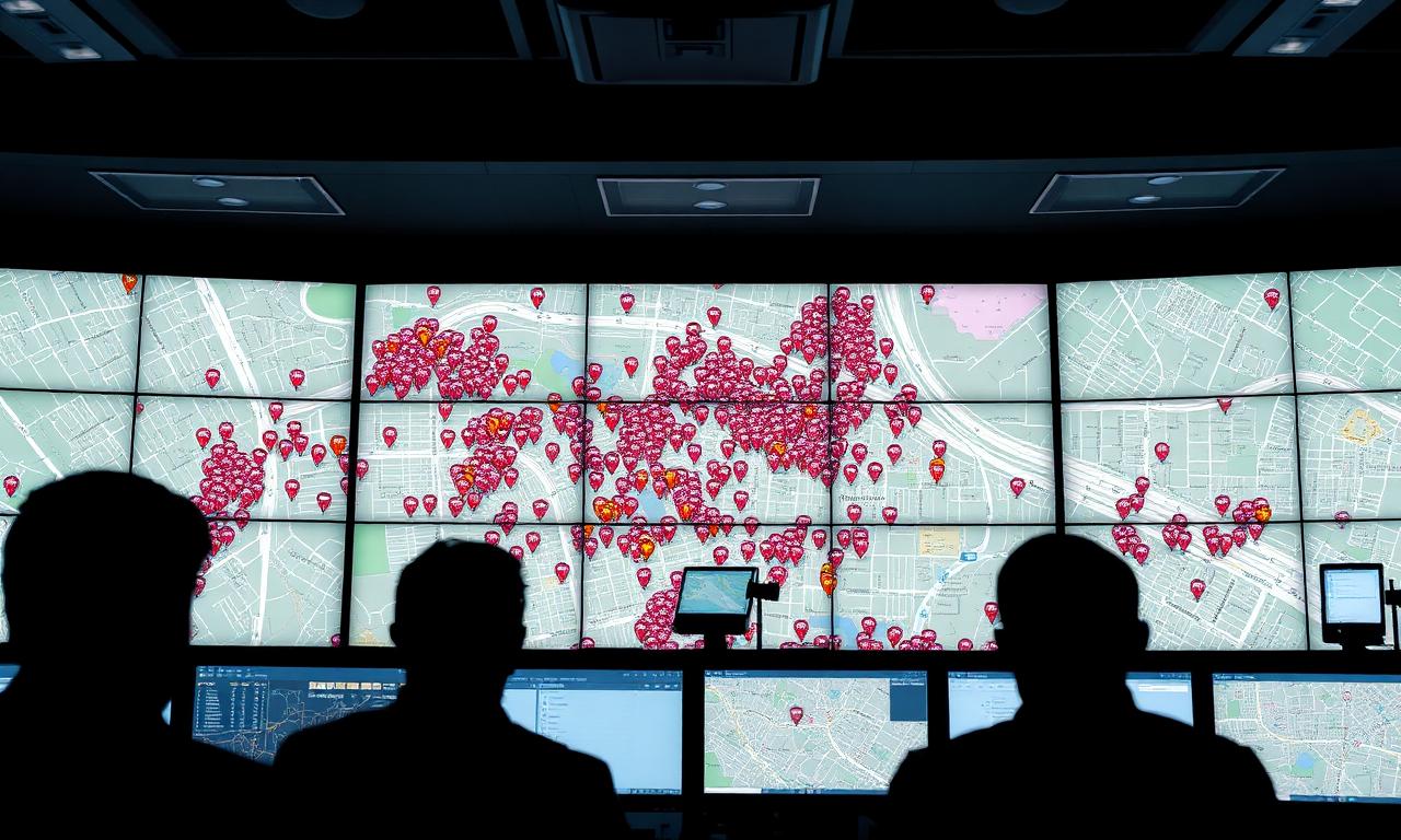
Live operations control room
See every worker on the map with live status, route and ETA.
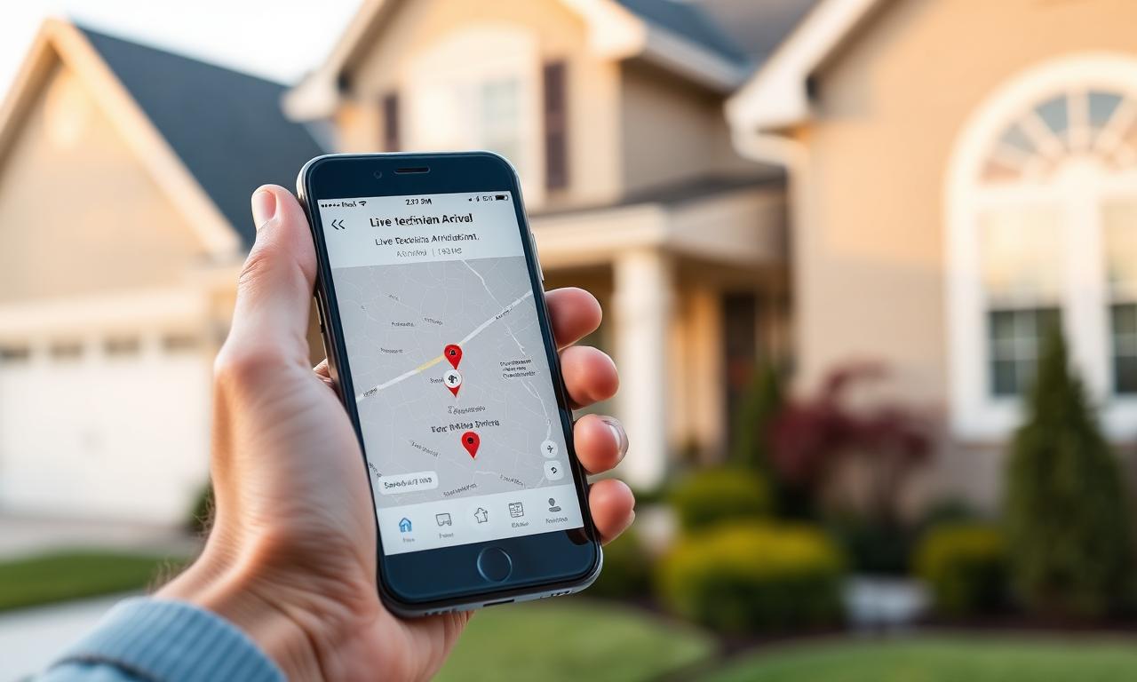
Customer ETA notifications
Share accurate arrival windows from live GPS instead of guesses.

Travel-time analytics
Review historic movement to optimise zones, depots and crew structures.
Mapping, GPS & User Tracking — questions answered.
How often does location update?+
In real time while the mobile app is active, with full movement history retained.
Can customers see ETAs?+
Yes — live ETAs can be surfaced in the client portal or via notifications.
Is geo-fencing supported?+
Yes. Define zones to auto-validate on-site arrival and departure.
What does mapping and GPS tracking do in a field service platform?+
Mapping and GPS tracking give your office team a live view of where field workers and vehicles are, where jobs are located and how work is distributed across regions. WorkWide Mobile uses that location data to support smarter dispatching, faster response times and better day-to-day visibility.
Can managers see technicians and jobs on one map?+
Yes. Technicians, vehicles, customer sites and active jobs appear on a single live map view. Managers can see who is closest to a new job, who is running behind and how work is spread across an area at any moment.
Does GPS tracking work for mobile technicians and vehicles?+
Yes. Location data is captured from technician devices and supported vehicle integrations, so you get visibility of both your people and your fleet in the same view — without running separate tracking systems.
How does mapping support better dispatching?+
Because dispatchers can see real locations rather than relying on guesswork, they can assign the nearest available technician, reduce unnecessary travel and respond faster to urgent jobs. That has a direct impact on travel cost, fuel use and customer wait times.
Is the location data used for anything beyond live tracking?+
Yes. Location and movement data feeds into reporting, route planning, SLA tracking and proof of attendance. Over time, that data helps your business identify trends, improve planning and demonstrate service delivery to customers.
Customer stories featuring this
Integrated Field Operations & Service Management for a major telecommunications infrastructure provider
Streamlining wireless and fibre task workflows from incident to invoicing, delivering real-time visibility, cross-team coordination, and centralized SLA reporting.
Read story Broadcast TechnologyNationwide Field Technician Enablement for a broadcast technology fulfilment partner
Scaling workforce management to drive massive increases in task volume, on-time completion, and fuel efficiency during digital television migration projects.
Read storySee Mapping, GPS & User Tracking live in your operation.
Book a call and we'll show you exactly how this works for your teams, sites and customers.
Related capabilities
Ready to get started?
Book a call and see WorkWide Mobile in action.